
Robot Vacuum Mapping Technology Explained: How a Machine Learns the Shape of Your Home
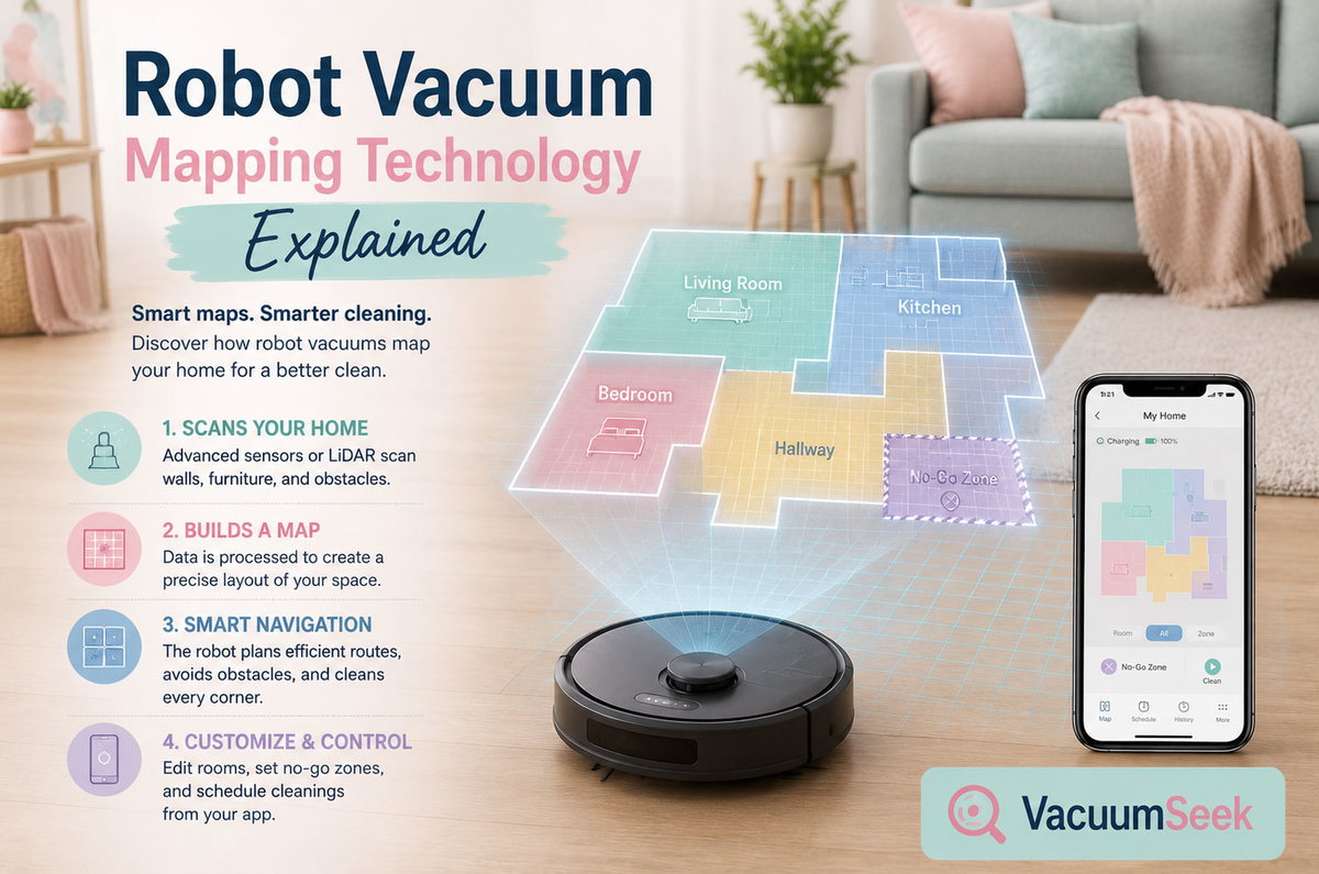
There was a time when a robot vacuum's idea of a floor plan was whatever wall it bumped into next. It would spin, reverse, veer off at a random angle, and eventually cover most of a room through sheer repetition rather than intelligence. Anyone who owned one of those early models remembers the sound: a soft thud against a table leg, a pause, a slow turn, and off it went again in a new direction, as clueless as before.
That era is over. Today's robot vacuums don't wander — they survey. Within minutes of being unboxed, a modern unit can scan a living room, identify a hallway, recognize a kitchen island, and store the whole layout as a digital floor plan it will reuse for years. This shift didn't happen by accident. It's the result of three overlapping technologies — LiDAR, visual SLAM, and increasingly sophisticated sensor fusion — maturing at the same time that home Wi-Fi, cheap processors, and machine learning became good enough to support them.
This piece breaks down exactly how that mapping works, what separates the technologies from one another, and what actually matters when you're comparing spec sheets that all claim "smart navigation."
The Short History: From Bumping Into Walls to Building Blueprints
The earliest widely sold robot vacuums, including the original Roomba generation from iRobot, relied on what engineers call reactive navigation. A bumper sensor detects contact, an infrared sensor detects a drop-off at a stair edge, and the robot's onboard logic decides which way to turn. No map is ever built. No memory of the room persists between cleaning sessions. It works, technically, in the same way that mowing a lawn with your eyes closed works — eventually.
The next leap came with gyroscope-assisted navigation, sometimes marketed as "systematic" cleaning. A gyroscope and accelerometer let the robot estimate roughly how far it has traveled and in which direction, so it can move in straighter lines and rows instead of pure randomness. It's an improvement, but the estimate drifts over time. Small errors compound, and after a few minutes the robot's internal sense of "where am I" no longer matches the real room.
Real mapping required a completely different approach: simultaneous localization and mapping, universally shortened to SLAM. Borrowed from robotics research used in autonomous vehicles and warehouse robots, SLAM lets a machine build a map of an unfamiliar space while simultaneously tracking its own position inside that map. It's a two-way problem — you need the map to know where you are, but you need to know where you are to build the map — and solving it in real time, on a battery-powered device the size of a dinner plate, is the actual engineering achievement behind every "smart" robot vacuum sold today.
The Three Main Mapping Technologies
Nearly every mapping robot vacuum on the market in 2026 uses one of three core sensing approaches, or a combination of them.
LiDAR: The Rotating Laser That Never Sleeps
LiDAR stands for Light Detection and Ranging. A small rotating turret, usually sitting slightly raised on top of the robot, fires laser pulses outward in a continuous 360-degree sweep. Each pulse bounces off a wall, a chair leg, or a doorframe, and returns to the sensor. By timing how long that round trip takes, the robot calculates the exact distance to that surface. Do this thousands of times a second while the robot moves, and you get a precise, continuously updated point-cloud map of the room.
The advantage of LiDAR is consistency. It doesn't care whether the lights are on, whether the walls are painted white or navy blue, or whether it's two in the morning. Distance is distance, laser pulses don't need ambient light to work, and the resulting maps tend to be geometrically accurate down to a few centimeters. That precision is why LiDAR has become the default navigation method for most flagship robot vacuums from brands like Roborock, Ecovacs, and Dreame.
LiDAR isn't flawless. Glass doors, mirrors, and highly reflective or jet-black surfaces can scatter or absorb the laser in ways that confuse distance readings. The rotating mechanism is also a physical moving part, which means it's one more component that can wear out over years of use. And because the hardware itself is more expensive than a basic camera or infrared sensor, LiDAR-equipped models have historically carried a price premium — though that premium has been shrinking fast as the technology becomes standard even in budget-tier vacuums.
vSLAM (Visual SLAM): Seeing the Room Like We Do
Visual SLAM takes a different route to the same goal. Instead of lasers, it relies on one or more onboard cameras that continuously photograph the environment as the robot moves. Software then identifies fixed reference points — the corner of a doorframe, the leg of a couch, a picture frame on the wall — and tracks how those landmarks shift in the camera's view from one frame to the next. From that shifting perspective, the robot calculates both its own movement and the layout of the room around it, essentially building a map out of thousands of overlapping photographs stitched together in real time.
The camera-based approach has a genuine edge in one area: recognition. Because it's actually looking at the floor rather than just measuring distance to it, a vSLAM-equipped robot — the kind used in many Roomba models — can be trained to recognize specific objects. That's the technology behind features that identify and steer around charging cables, shoes, pet waste, or a forgotten sock, rather than just registering "obstacle, turn." It also tends to be cheaper to manufacture, since decent cameras cost less than a spinning laser assembly.
The tradeoff is dependence on light. A dark room, a blacked-out hallway at night, or a plain white wall with no visual texture can all make it harder for a camera to find reliable landmarks, which is why vSLAM robots have historically been more prone to getting lost in dim conditions than their LiDAR counterparts. Recent advances in low-light image processing and machine-learning-trained object recognition have narrowed that gap considerably, but it hasn't disappeared entirely.
Structured Light and Time-of-Flight: The Hybrid Newcomers
A newer category blends the strengths of both worlds. Structured-light systems project a specific pattern of infrared dots or lines onto the environment and read how that pattern deforms across surfaces to calculate depth — similar in principle to how some smartphone face-recognition cameras work. Direct time-of-flight (dToF) sensors go a step further, using pulsed light to measure depth the way LiDAR does but through a compact, often solid-state module rather than a full rotating assembly.
These hybrid systems increasingly appear alongside LiDAR and cameras in premium models, giving the robot layered depth perception: one sensor for long-range mapping accuracy, another for close-range obstacle detail like distinguishing a phone charger from a rug tassel. Some newer designs even let the sensor housing physically shift height, dropping low enough to scan the gap beneath a sofa and rising for a wide-angle sweep of an open room — a small mechanical trick that meaningfully improves under-furniture navigation.
Gyroscope and Bump Sensors: The Budget Baseline
It's worth naming the fourth category honestly, because it still exists on store shelves. Entry-level robot vacuums that rely purely on gyroscopes, accelerometers, and bump sensors don't build a true map at all. They estimate a path using dead reckoning and mechanical contact. These models are cheaper, simpler, and perfectly serviceable for a small studio apartment with few obstacles, but they cannot offer room-specific cleaning, no-go zones, or reliable multi-floor memory, because there's no persistent map to base those features on.
How SLAM Actually Works, Step by Step
It's easy to treat "SLAM" as marketing shorthand, but the underlying process is genuinely elegant once you break it into stages.
- Sensing. The robot's LiDAR, camera, or depth sensor continuously captures raw data about distances and features in its surroundings.
- Feature extraction. Software identifies distinct, trackable points in that raw data — corners, edges, distinct shapes — that can be recognized again from a slightly different angle a second later.
- Motion estimation. By comparing how those features shifted between two moments in time, the robot calculates how far and in which direction it has actually moved, cross-checked against its wheel odometry and gyroscope.
- Map building. Each new sweep of data gets stitched onto the growing map, gradually filling in walls, furniture boundaries, and open floor space.
- Loop closure. When the robot revisits a location it has already mapped, it recognizes the overlap and corrects any small drift that accumulated along the way — this is the step that keeps the whole map from slowly warping into an inaccurate shape over a long cleaning run.
- Localization. At every moment, the robot compares live sensor data against the map it has built so far to answer one constant question: where exactly am I right now?
That loop — sense, estimate, map, correct, locate, repeat — runs dozens of times per second. It's the same fundamental process used in self-driving cars and warehouse logistics robots, just scaled down to fit inside a machine that also has to empty a dustbin and avoid the dog.
LiDAR vs. vSLAM vs. Hybrid: A Side-by-Side Comparison
| Feature | LiDAR Navigation | vSLAM (Camera) Navigation | Hybrid (LiDAR + Camera/ToF) |
|---|---|---|---|
| How it senses distance | Rotating laser measuring time-of-flight | Camera images matched against landmarks | Laser plus camera/structured light layered together |
| Works in the dark | Yes, fully | Limited — needs some ambient light | Yes, laser layer covers low light |
| Mapping accuracy | Very high, centimeter-level | Good, improving fast with AI | Highest, combines strengths |
| Object recognition | Basic — detects shape, not identity | Strong — can identify specific objects | Strong, plus precise distance data |
| Common weak point | Glass, mirrors, very dark surfaces | Low light, plain untextured walls | Higher cost, more components |
| Typical hardware cost | Moderate to high | Lower | Highest |
| Best suited for | Homes with varied lighting, larger layouts | Budget-conscious buyers, clutter-heavy homes | Buyers who want maximum reliability |
| Example use case | Cleaning at night without losing position | Avoiding a charging cable or pet bowl | Both at once, in real time |
No single row on that table crowns an outright winner, because the "best" mapping technology depends entirely on the home it's cleaning. A single-level apartment with consistent lighting and few obstacles doesn't need the same sensor stack as a multi-story house with a dim basement and two dogs.
Beyond the First Map: No-Go Zones, Multi-Floor Memory, and Smart Home Integration
Building an accurate map is only step one. What actually makes mapping useful day to day is what the companion app lets you do with it afterward.
No-go zones and virtual barriers let a homeowner draw digital boundaries directly onto the saved map — around a pet's water bowl, a cluster of charging cables, or a delicate rug — without needing any physical barrier strip on the floor. Some higher-end systems now offer over a dozen simultaneous exclusion zones.
Room-by-room and zone cleaning relies entirely on the map being segmented into logical spaces. Because the robot understands which coordinates belong to the kitchen versus the hallway, a user can tap "clean only the kitchen" in the app and the robot will navigate directly there rather than sweeping the entire floor.
Multi-floor mapping has become one of the more meaningful upgrades of the past two years. Most current mapping robot vacuums can store several saved floor plans — typically four or five — and automatically detect which floor they're currently on using landmark recognition, so a household can carry the same robot between an upstairs bedroom level and a downstairs living area without forcing a full re-map every time.
Smart home integration ties the whole system together. Saved maps and room labels sync with voice assistants, so a request like "clean the upstairs bedroom" can trigger a floor-specific and room-specific cleaning run without opening an app at all.
None of these conveniences exist without a persistent, structured map underneath them. That's the real value proposition of mapping technology — not the map itself, but everything a household can build on top of it once it exists.
The Privacy Question Nobody Talks About Enough
A robot that builds a detailed floor plan of your home is, by definition, collecting sensitive spatial data: room dimensions, furniture placement, and in camera-equipped models, actual visual footage of your living space. That data typically syncs to a manufacturer's cloud servers to enable app features like remote scheduling and multi-floor memory.
This is worth taking seriously rather than dismissing as paranoia. Before buying, it's reasonable to check a manufacturer's stated data policy: whether maps are stored locally or in the cloud, whether footage from onboard cameras is ever reviewed by humans for AI training purposes, and whether that data can be deleted on request. Reputable manufacturers publish this information directly — iRobot's privacy documentation, Roborock's support pages, and Ecovacs' policy pages are reasonable starting points for that research. A few extra minutes reading the fine print is a small price for peace of mind about a device that, quite literally, maps your home's interior.
Choosing the Right Mapping Technology for Your Home
A few practical questions tend to cut through the spec-sheet noise faster than anything else.
How much natural and artificial light does the space get? A consistently bright home with big windows plays to vSLAM's strengths. A home with dim hallways, a basement, or a preference for night-time cleaning runs favors LiDAR.
How cluttered is the floor day to day? Households with kids, pets, or a lot of loose cables benefit disproportionately from camera-based object recognition, even layered on top of LiDAR's positioning accuracy.
How many floors need coverage? Multi-floor households should specifically confirm the saved-map limit, since a robot that only remembers one layout will re-map the entire space every time it changes levels — a frustrating and time-consuming reset.
What's the actual floor plan complexity? Open-concept layouts with few walls are forgiving of almost any mapping technology. Segmented homes with many small rooms, tight doorways, and irregular shapes reward the higher positional accuracy that LiDAR and hybrid systems provide.
What's the budget ceiling? LiDAR-based mapping, once a strictly premium feature, has moved decisively into the sub-$300 category over the past two years, which means the real budget decision today is less about "map or no map" and more about how many sensor layers, how much suction, and how much app polish a buyer wants to pay for.
The Road Ahead: Where Mapping Technology Goes Next
Mapping is quietly becoming less about geometry and more about understanding. The next generation of onboard machine learning models isn't just measuring where a wall is — it's increasingly trained to recognize what it's looking at: a charging cable versus a shoelace, a rug edge versus a step down, a pet versus a paper bag left on the floor. That shift from measurement to recognition is the same trajectory computer vision has followed everywhere else, from smartphone cameras to autonomous vehicles, and robot vacuums are simply the latest, humblest beneficiary of it.
Expect three trends to keep accelerating. First, sensor fusion — combining LiDAR, cameras, and depth sensors into a single unified map rather than treating them as separate systems — will keep becoming the default rather than the premium exception. Second, three-dimensional mapping, which accounts for vertical clearance under furniture and around low-hanging obstacles rather than just a flat floor plan, will keep improving how well robots navigate genuinely cluttered homes. Third, on-device AI processing will reduce how much raw data needs to leave the home at all, addressing some of the privacy concerns outlined above while also making the robots faster and less dependent on a stable internet connection.
None of this changes the core physics of SLAM — sense, estimate, map, correct, locate, repeat — but it does mean the map your next robot vacuum builds will understand your home in a genuinely richer way than the one it builds today.
Frequently Asked Questions
Does every robot vacuum build a map? No. Entry-level models using only bump sensors and gyroscopes clean via estimated paths and don't retain a persistent map between cleaning sessions, which means they can't offer room-specific cleaning or no-go zones.
Is LiDAR better than a camera for robot vacuum navigation? Neither is universally better — LiDAR generally wins on raw positional accuracy and works in complete darkness, while camera-based vSLAM tends to win on identifying specific objects on the floor. Many premium models now use both together.
Can a robot vacuum remember more than one floor of a house? Most current mapping-capable models can store multiple saved floor plans, commonly four or five, and automatically detect which floor they're on using landmark recognition, though the exact limit varies by model.
Do robot vacuums need Wi-Fi to map a home? No. Mapping itself happens onboard using the robot's own sensors and processor. Wi-Fi is only required for companion app features like remote scheduling, voice assistant integration, and cloud backup of saved maps.
Is it safe to let a robot vacuum map my home? It's a reasonable question to ask of any connected device. Checking a manufacturer's specific data policy on map storage, camera footage handling, and deletion options is worth the few minutes it takes before purchase.
Final Thoughts
The distance between a robot that randomly bumps around a living room and one that builds a precise, editable floor plan of an entire multi-story home is, in engineering terms, enormous — and yet it's happened quietly enough that most people barely noticed the transition. LiDAR, visual SLAM, and the hybrid sensor systems now emerging all solve the same underlying problem in different ways: how does a machine know where it is, and where it still needs to go?
Understanding that underlying problem makes the marketing language on any given box far easier to decode. A "smart map," a "no-go zone," and a "multi-floor memory" are not separate features bolted on for the sake of a longer spec sheet — they're all downstream consequences of one robot successfully answering that one question, over and over, room by room, floor by floor, for years of cleaning cycles to come.
Further Reading and Resources
- iRobot — official product and privacy documentation for Roomba's vSLAM-based lineup
- Roborock — LiDAR mapping specifications and companion app details
- Ecovacs — TrueMapping LiDAR technology overview
- Dreame — hybrid LiDAR and structured-light navigation systems
- Vacuum Wars — independent lab testing and navigation comparisons
- TechGearLab — annual robot vacuum rankings and mapping performance reviews